
The most accurate way to measure a roof without a tape measure is already in your pocket. Yet thousands of roofing professionals still climb ladders with clipboards, scribble down numbers, and spend their evenings manually sorting photos and building reports from scratch. That’s not a workflow. That’s a time tax.
You already know the frustration: one bad measurement means wasted materials, a lost bid, or a delayed claim. The physical risk of every unnecessary roof climb adds up too. The good news is that photo-based roof measurement software has fundamentally changed what’s possible on a modern jobsite, and the best platforms don’t stop at measurements. They automate the entire documentation chain, from aerial data capture to a polished, professional inspection report, in minutes.
This guide cuts through the noise. You’ll learn exactly how to evaluate and use the right tools to measure faster, document smarter, and close more claims and bids with confidence. We’ll cover how aerial measurements integrate with automated photo reporting, what to look for in a platform built for field professionals, and how teams are saving serious time on every single inspection.
Key Takeaways
- Photo-based roof measurement software has evolved far beyond basic calculations – today’s platforms deliver pitch, area, and dimensional data from high-resolution aerial imagery, eliminating the need for dangerous manual roof climbs.
- Not all measurement technologies are equal: you’ll discover the real cost-benefit difference between ordering satellite reports and using DIY measuring apps, so you can choose the right tool for your volume and budget.
- The biggest time drain isn’t taking measurements – it’s the documentation gap that follows. Learn why organizing and labeling 100+ photos per property is the number-one bottleneck slowing adjusters and contractors down.
- Choosing the right roofing software means evaluating integration with tools like Xactimate and Verisk, plus a field-ready interface that works for professionals on the job – not just in the office.
- PHOTO iD bridges aerial data and professional reporting in one platform, automating the entire inspection workflow so your team saves serious time on every single job.
What is Roof Measurement Software? Defining Accuracy in 2026
Roof measurement software is a digital platform that calculates a roof’s total area, pitch, slope, and linear dimensions using imagery, sensor data, or a combination of both. Think of it as replacing the clipboard, the tape measure, and the ladder with a single intelligent system that delivers the numbers you need before you’ve even laced up your boots.
The shift away from manual measurement has been decisive. Where field professionals once climbed every structure to record figures by hand, high-resolution aerial imagery now delivers verified dimensional data from ground level. The safety impact is real: reducing unnecessary roof access dramatically cuts exposure to fall risk, which remains one of the leading causes of serious injury in the construction and inspection trades.
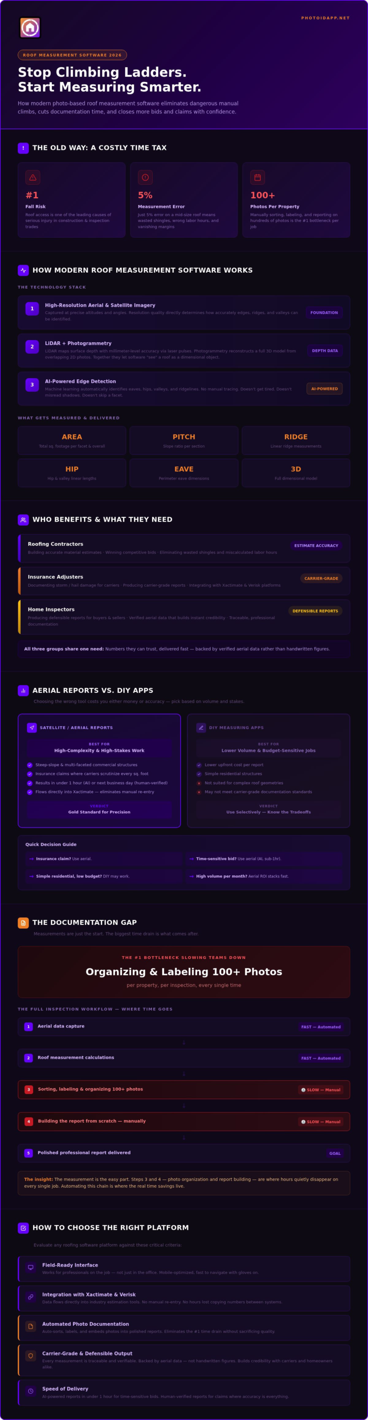
The professionals driving adoption of photo-based roof measurement software fall into three clear groups: roofing contractors building accurate material estimates, insurance adjusters documenting storm or hail damage for carriers, and home inspectors producing defensible reports for buyers and sellers. Each group shares the same core need: numbers they can trust, fast.
The Core Components of Modern Roofing Tech
Modern platforms pull from multiple data sources to build a complete picture of any structure. Here’s how the technology stack actually works:
- High-resolution aerial and satellite imagery: Captured at precise altitudes and angles, this imagery provides the raw visual foundation. Resolution quality directly determines how accurately edges, ridges, and valleys can be identified.
- LiDAR and photogrammetry: LiDAR uses laser pulses to map surface depth with millimeter-level accuracy. Photogrammetry reconstructs a 3D model from overlapping 2D photographs. Together, they allow software to “see” a roof as a dimensional object rather than a flat image.
- AI-powered edge detection: Machine learning algorithms automatically identify eaves, hips, valleys, and ridgelines, eliminating the manual tracing that used to slow down report generation. The AI doesn’t get tired, doesn’t misread shadows, and doesn’t skip a facet.
Why Precision Matters for Your Bottom Line
A measurement error of just five percent on a mid-size residential roof can translate to wasted shingles, miscalculated labor hours, and a margin that quietly disappears before the job is even complete. Repeated across dozens of jobs per month, that gap compounds fast.
Precision also builds credibility. When a homeowner or insurance carrier sees a report backed by verified aerial data rather than a handwritten figure, trust closes faster than any sales pitch. In the context of insurance-ready documentation, precision means every measurement is defensible, traceable, and carrier-grade from the moment it’s generated.
Aerial vs. DIY: Comparing Modern Measurement Technologies
Not every job calls for the same measurement approach. The right tool depends on your volume, your timeline, and the stakes attached to the numbers you’re delivering. Get this choice wrong and you’re either overpaying for data you didn’t need or underequipping yourself on a complex claim that demands precision.
Satellite and Aerial Reports: The Gold Standard
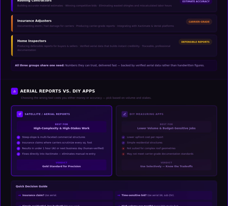
Professional aerial measurement reports are built for high-complexity, high-stakes work. Steep-slope roofs, multi-faceted commercial structures, and insurance claims where a carrier will scrutinize every square foot all benefit from verified aerial data. These reports combine satellite imagery with photogrammetry and LiDAR-derived depth data to produce pitch, area, ridge, hip, valley, and eave measurements in a single deliverable.
Delivery timelines vary by provider. Some platforms return results in under an hour using AI-automated processing; others offer human-verified reports that may arrive the next business day. For time-sensitive bids, speed matters. For carrier-grade documentation, that human verification layer can be the difference between an accepted claim and a disputed one.
Aerial data also integrates directly into estimation software. When your measurements flow cleanly into platforms like Xactimate, you eliminate the manual re-entry step that quietly eats hours across a busy month.
One often-overlooked advantage: wall measurements. Full-envelope jobs covering both roofing and siding require accurate linear wall data, not just roof area. Professional aerial reports that include wall dimensions save contractors from a second site visit and give adjusters a complete picture of storm damage in one document.
Mobile DIY Apps: Speed and Flexibility
Smartphone-based measuring apps have matured fast. Devices equipped with LiDAR sensors can now capture on-site dimensional data with enough accuracy for rapid triage, preliminary estimates, and virtual inspections that eliminate unnecessary site visits entirely.
The speed advantage is real. Pull up an address, capture a few angles, and have working numbers in minutes. For contractors running high-volume residential work, that pace is a genuine competitive edge during storm season.
The honest limitation is verification. DIY satellite measuring tools still rely on human tracing, and human tracing introduces human error. For insurance claims or large commercial bids, that risk compounds. The smart workflow pairs a fast DIY capture for initial triage with a verified aerial report for final documentation on anything high-stakes.
Photo-based roof measurement software that bridges both worlds, combining field-captured imagery with automated reporting, closes the gap between speed and accuracy. See how PHOTO iD connects aerial measurements to polished inspection reports without the manual steps that slow your team down.
The Documentation Gap: Why Measurements Alone Are Not Enough
You’ve got the numbers. Pitch, area, ridge length, total squares. The aerial report is accurate, the data is clean, and you’re ready to build a case. Then reality hits: 130 photos sitting in your camera roll, none of them labeled, half of them looking identical, and a report due in two hours. That’s the documentation gap, and it swallows the time that accurate measurements were supposed to save you.
Measurements solve one problem. Documentation solves a completely different one. For insurance adjusters especially, the bottleneck isn’t calculating damage, it’s organizing, labeling, and sequencing photos in a way that tells a coherent story to a carrier. On a complex storm claim, that process can consume more time than the physical inspection itself. Every unlabeled photo is a decision deferred until you’re back at a desk, tired, working from memory that’s already fading.
This is where most photo-based roof measurement software stops short. It hands you the data and leaves the documentation to you. That gap is where claims slow down, bids lose their edge, and hours disappear.
Automating the Field Documentation Process
Voice-to-text labeling changes the equation entirely. Instead of photographing damage and hoping you’ll remember what you were looking at three hours later, you narrate in real time. Snap the photo, speak the label, move on. The app captures both simultaneously, eliminating what field professionals call “photo amnesia,” that frustrating moment at the office when 40 images of granule loss all look the same and none of them are named.
Automated labeling doesn’t just organize your files. It compresses your entire post-inspection workflow. Instant photo report generation means a polished, client-ready document can be shared the moment you leave the property, not the following morning. For adjusters, automated labeling directly reduces claim cycle times by eliminating the manual sort-and-label step that sits between field capture and carrier submission.
Custom Templates for Standardized Inspections
Consistency is a team problem as much as an individual one. When every inspector follows their own mental checklist, report quality varies, coverage gaps appear, and supervisors spend time correcting rather than closing. Custom inspection templates solve this at the source.
Building separate templates for wind, hail, and maintenance inspections ensures every team member captures the same data points in the same sequence, every time. Software prompts guide the inspector through each required photo and notation, keeping workflows aligned with IICRC standards and carrier documentation requirements without relying on memory or experience level.
The result is a team that scales without sacrificing quality. New inspectors perform at the same documentation standard as veterans because the workflow itself carries the knowledge. PHOTO iD’s custom templates and voice-to-text labeling give your team that infrastructure, turning every site visit into a structured, repeatable, defensible inspection from the first photo to the final report.
How to Choose the Best Roofing Software for Your Team
The market is crowded. Every platform promises speed, accuracy, and simplicity, but those claims look very different once a crew of six is running storm inspections across three counties and the office manager is trying to track progress in real time. Choosing the right photo-based roof measurement software isn’t just a technology decision. It’s an operational one, and the wrong call costs you more than a subscription fee.
Start with your workflow, not the feature list. Ask one question first: does this software fit how my team actually works, or does my team have to change how they work to fit the software? The answer tells you everything.
Integration and Workflow Compatibility
For insurance restoration contractors and adjusters, Xactimate integration isn’t a nice-to-have. It’s the non-negotiable. If your measurement data can’t flow directly into your estimating environment, you’re re-entering numbers by hand, and that’s where errors multiply. Look for platforms that export clean, structured data that Xactimate reads without reformatting.
Beyond Xactimate, check for Verisk compatibility and PDF or CAD export options. Material ordering workflows often require dimensional data in formats that your supplier’s system can process directly. A platform that traps your data inside its own ecosystem slows you down the moment you step outside it.
Cloud-based syncing is equally critical. When a field tech captures measurements on-site, that data should appear in the office dashboard immediately, not after a manual upload at the end of the day. Real-time sync eliminates the version-control problems that quietly derail multi-crew operations.
User Experience and Mobile Reliability
Here’s a test most software demos skip: can you navigate the app wearing work gloves, in direct sunlight, with wind noise in the background? If the interface requires precise taps on small targets or voice commands that only register in quiet conditions, it will fail in the field.
Offline mode isn’t optional. Rural properties, basements, and metal structures all create dead zones where 5G doesn’t reach. Your software must capture, label, and store data locally and sync when connectivity returns. A platform that freezes mid-inspection because of a weak signal isn’t a field tool. It’s a liability.
Voice-to-text accuracy under real jobsite conditions matters too. Wind, traffic, and ambient noise are constants on any active site. Test the feature outside, not in a quiet office demo.
For team leads and supervisors, the centralized dashboard is where the ROI becomes visible. Tracking multiple crews across active projects, monitoring inspection completion status, and flagging incomplete documentation before a report goes to a carrier: that’s the difference between managing chaos and running a tight operation.
PHOTO iD’s real-time team management dashboard gives supervisors that visibility without requiring a phone call to every tech in the field. See how PHOTO iD’s team management features keep your entire operation aligned from the first inspection to the final report.
Streamline Your Inspections with PHOTO iD’s Integrated Suite
Every tool covered in this guide solves part of the problem. PHOTO iD solves the whole thing. Built by Ken Perry, known across the industry as “The Claims Coach,” the platform was designed by someone who has lived the documentation bottleneck firsthand. That expertise shows in every feature. This isn’t generic photo-based roof measurement software repurposed for field work. It’s an integrated suite purpose-built for the professionals who can’t afford to lose an hour to administrative chaos.
The aerial roof and wall measurements feature delivers the comprehensive dimensional data contractors and adjusters need: pitch, total area, ridge, hip, valley, and linear wall measurements in a single pull. No second site visit. No manual re-entry. The data flows directly into your reporting workflow, closing the gap between raw measurement and finished documentation faster than any standalone measurement tool can manage.
The Power of Voice-to-Text Labeling
Stop typing. Start talking. PHOTO iD’s voice-to-text labeling lets you narrate each photo the moment you capture it, hands-free, while you’re still standing on the roof. Snap the image, speak the label, move to the next item. The app locks both together instantly.
The downstream effect is significant. When you leave the property, your photos are already organized, labeled, and sequenced. Instant photo report generation means a polished, carrier-ready document is ready to share before you’ve reached your truck. Across a full inspection calendar, that compression of post-field office time is where the real savings accumulate. Custom inspection templates standardize this process across your entire team, so every inspector, regardless of experience level, captures the same data points in the same order on every single job.
Virtual Inspection and Remote Management
Not every claim demands a physical site visit at the triage stage. PHOTO iD’s virtual inspection capability lets adjusters and contractors assess properties remotely, using aerial measurements and field-captured imagery to qualify damage, prioritize complex claims, and allocate crew time where it’s actually needed. Faster triage means faster cycle times and fewer unnecessary ladder climbs.
The team management dashboard brings everything into focus from one screen. Track active inspections, monitor photo capture progress, and flag incomplete documentation before a report ever reaches a carrier. Supervisors get real-time visibility without chasing down field techs by phone. It’s the operational infrastructure that turns a busy team into a tight, scalable operation.
Snap it. Label it. Report it. That’s the PHOTO iD workflow, and it’s the edge your team needs right now. Experience the speed of PHOTO iD – Get started now!
Your Next Inspection Starts Here
The gap between a good inspection and a great one isn’t talent. It’s tooling. Photo-based roof measurement software has matured to the point where precision aerial data, automated photo labeling, and polished carrier-ready reports can all live in a single platform, and the teams adopting that workflow are closing faster, documenting better, and spending less time on administrative cleanup after every job.
Three things stand out from everything covered here: accurate measurements only solve half the problem, documentation speed determines your real competitive edge, and the right platform should fit your field workflow from the first photo to the final report. Automated photo labeling saves up to an hour per report. Aerial measurements deliver precision you can defend. And with PHOTO iD built by industry veteran Ken Perry, you’re not learning software from a tech company that’s never climbed a roof.
The ladder stays on the truck. The reports go out faster. Your team scales without the chaos. Stop climbing ladders and start closing deals with PHOTO iD!
Frequently Asked Questions About Photo-Based Roof Measurement Software
How accurate is aerial roof measurement software compared to manual measuring?
Aerial roof measurement software consistently matches or outperforms manual measuring in real-world conditions. Human measurement introduces errors through miscounted courses, misread tape positions, and transcription mistakes that compound across a full estimate. Platforms using LiDAR and photogrammetry eliminate those variables entirely, delivering pitch, area, and linear dimensions from verified imagery without anyone touching a tape measure.
The practical difference shows up on complex roofs. Multi-faceted structures with multiple pitch changes are notoriously difficult to measure manually. Aerial data captures every facet simultaneously, so nothing gets missed and nothing gets estimated.
Does roof measurement software work for both residential and commercial properties?
Yes, and the distinction matters less than most people expect. Residential roofs benefit from speed and safety advantages, while commercial structures benefit most from the precision aerial data delivers on large, low-slope, or complex membrane roofs where manual measurement is genuinely impractical. The same platform handles both property types without requiring different tools or workflows.
For commercial jobs specifically, aerial wall measurements add real value. Full-envelope estimates covering roofing and cladding require accurate linear wall data, and getting that from a single aerial pull eliminates a second site visit entirely.
Can I integrate roof measurement data directly into Xactimate?
The best photo-based roof measurement software platforms export structured data that flows cleanly into Xactimate without manual re-entry. Look for platforms that confirm direct Xactimate compatibility and check whether they also support Verisk and CAD or PDF export formats, since different carrier workflows require different output types. If a platform traps your data inside its own ecosystem, you’re adding a manual step every single time.
Verify current integration capabilities directly with any provider before committing, since software partnerships and export formats do evolve. The goal is clean data transfer from measurement capture to estimate, with zero reformatting in between.
Do I need a drone to get accurate roof measurements with PHOTO iD?
No. PHOTO iD’s aerial roof and wall measurements are delivered through the platform’s integrated aerial data service, so you don’t need to own, operate, or license drone equipment. The measurements are generated from high-resolution aerial imagery and processed through the platform, giving you pitch, total area, ridge, hip, valley, and wall dimensions without any hardware investment beyond your mobile device.
This matters operationally. Drone programs require FAA certification, insurance, equipment maintenance, and weather-dependent scheduling. PHOTO iD removes all of that friction and delivers the data you need faster than most drone workflows can mobilize.
How does automated photo labeling save time for field adjusters?
The time savings come from eliminating what happens after the inspection, not during it. Without automated labeling, an adjuster returns to the office with 100-plus unlabeled photos and spends an hour or more sorting, identifying, and naming each one from memory. Automated voice-to-text labeling captures the description at the moment of capture, so every photo arrives already identified, sequenced, and ready to drop into a report.
Multiply that saved hour across a full inspection calendar during storm season and the operational impact is significant. Faster documentation means faster carrier submission, shorter claim cycles, and more inspections completed per day without sacrificing report quality.
Is there a mobile app that allows for voice-to-text photo labeling?
PHOTO iD includes voice-to-text labeling as a core feature of its mobile app. You capture the photo, speak the label hands-free, and the app locks both together instantly. The workflow is designed for real jobsite conditions, not quiet office demos, so it handles ambient noise, wind, and the physical realities of working on an active roof or exterior inspection.
The key advantage over typing labels manually is continuity. You stay focused on the inspection rather than shifting attention to a keyboard. Every label gets recorded in real time, which means your photo set is organized before you leave the property.
How long does it take to generate a full inspection report?
With PHOTO iD’s instant photo report generation, a polished, client-ready report can be produced and shared immediately after the inspection is complete. Because photos are labeled in real time during the inspection using voice-to-text, there’s no post-field sorting step. The documentation work happens on-site, so the report is ready the moment you wrap up, not the following morning.
Aerial measurement delivery times vary by provider and report type. AI-automated processing can return dimensional data in under an hour; human-verified reports may take longer. For time-sensitive bids, confirm turnaround expectations with your provider before the job starts.
Can I manage multiple roofing crews through one software dashboard?
PHOTO iD’s team management dashboard gives supervisors real-time visibility across all active inspections without requiring phone calls to individual field techs. You can track inspection progress, monitor photo capture completion, and flag incomplete documentation before a report reaches a carrier, all from a single screen.
This centralized view is where the operational value becomes tangible for growing teams. New inspectors follow the same structured workflow as veterans through custom inspection templates, so quality stays consistent regardless of crew size or experience level. Scaling up doesn’t mean scaling your supervision workload at the same rate.